Been There Done That

by Jon Burch Photography
Title
Been There Done That
Artist
Jon Burch Photography
Medium
Photograph - Digital Photography
Description
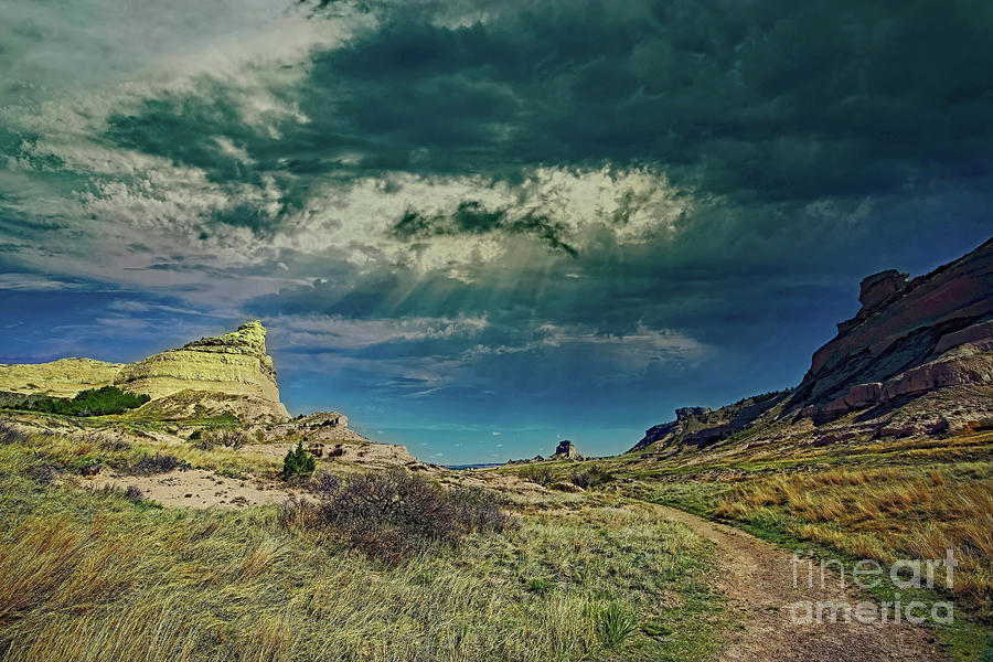
Once past Eagle Rock at Scott’s Bluff National Monument near Gering, Nebraska the wagon train emigrants could look back east and see a quartet of interesting rocks. To the left looking like a halved dome, Eagle Rock stands 4,482 feet above sea level. This large rock forms the north side of Mitchell Pass through which thousands of emigrants drove their covered wagons single file and Pony Express riders galloped to deliver mail.
The butte in the center is 4,396 feet above sea level. According to early emigrant diaries, Dome Rock reminded pioneers of the capitol dome because of its peculiar shape. The name was officially adopted by the United States Geological Service on June 11, 1941 after being submitted by the National Park Service. Over the years, Dome Rock has been referred to by many names such as a tower, spire, lighthouse, castle, church and a cathedral. At one time, Charles Gering owned half of Dome Rock and the National Park Service owned the other half. The Oregon Trail Museum Association purchased Gering’s half which was later sold to the National Park Service.
To the right of Dome Rock, Crown Rock sits as a promontory 4,557 feet above sea level. Visible from the Old Oregon Trail Highway 92, early pioneer diary accounts mention that men would climb up here and roll rocks down on wolves in the trees below to see them run. The crown is the knob of rock on top of the summit.
To the far right, Sentinel Rock forms the south abutment of Mitchell Pass at Scott’s Bluff National Monument. The rock is named for the comparatively small block standing like a watch tower against the sky. Formed by layers of strata eroding away, it was originally referred to as Sentinel Hill. There is a tradition that this pinnacle as well as a portion of Scotts Bluff adjoining Mitchell Pass on the north, was used as an observation tower. This squat column is on the end of the bluff is 4,390 feet above sea level.
Looking back toward these four rocks west of Scott’s Bluff, departing emigrant wagon tracks can still be seen on the Nebraska prairies. Their route west was arduous and fraught with many dangers, the number of deaths on the trail is not known with any precision and we only have wildly varying estimates. Estimating deaths on the trail is difficult because of the common practice of burying people in unmarked graves intentionally disguised to avoid being dug up by animals or robbers. Graves were often put in the middle of the trail and then run over by livestock to make them difficult to find. Disease was the main killer, cholera killed up to 3 percent of the travelers in the epidemic years from 1849 to 1855.
Some digital effects were applied to the original image after the photograph was made. No electrons were harmed during the transition. Your finished photograph will not contain the Fine Art America watermark.
Image copyright 2021 Jon Burch Photography.
Uploaded
May 26th, 2021
Statistics
Viewed 120 Times - Last Visitor from Ottawa, ON - Canada on 04/24/2024 at 10:24 PM
Embed
Share
Sales Sheet


